Pompei. Necropoli di Porta di Sarno. Tombe
monumentale e tombe sannitiche.
Pompeii. Porta Sarno Necropolis.
Monumental Tombs and Samnite tombs.
The necropolis is currently not accessible to visitors since it is located beyond the Circumvesuviana railway line.
Excavations
1910
Nel 1910 lo Spano registra a Porta di
Nola una "via di circonvallazione": Secondo Senatore "Nel 1908, nello scavo
dell’area fuori Porta di Nola, venne alla luce l’inizio di una ‘via di circonvallazione’
che si dirigeva verso Porta di Sarno rimanendo discosta circa 9 metri dalle
mura."
In 1910 Spano records a "ring road" at Porta di Nola: Senatore comments "In 1908, in the excavation of the area outside Nola Gate, the beginning of a 'ring road/bypass' came to light, heading towards Sarno Gate and remaining about 9 meters from the walls."
See Notizie
degli Scavi di Antichità, 1910, pp. 385-7.
See Senatore F,
1999. Necropoli e
società nell’antica Pompei: In Pompei, il Vesuvio e la Penisola Sorrentina, p. 110, Note 76.
1998
Nell’estate del 1998, a circa 80 m. dalla cinta muraria è
venuta alla luce una necropoli di età romana (al di sotto della quale si
trovavano le tombe sannitiche): “la necropoli sembra essere stata abbandonata
già prima dell’eruzione del 79 d.C.”
In the summer of 1998, about 80 m from the walls came to light a necropolis from Roman times (below which were Samnite graves): "the cemetery seems to have been abandoned even before the eruption of 79 A.D."
See Pompeii. Vesuvius AD 79, ‘Semestrale di
Informazione e Cultura’, Autunno - Inverno 98/99, p. 4.
See Senatore F,
1999. Necropoli e
società nell’antica Pompei: In Pompei, il Vesuvio e la Penisola Sorrentina, p. 111.
Scavi e scoperte nel suburbio
di Pompei: Rivista di Studi Pompeiani IX, 1998, p. 197-9.
I saggi
preliminari eseguiti in occasione del progetto di raddoppio della linea
ferroviaria Circumvesuviana, nel tratto Torre Annunziata - Scafati, misero in
luce - nell'area fuori le mura, circa 80 m ad est dell'Anfiteatro – tratti di
muratura di età romana in crollo. In seguito a ciò, fu avviata una campagna di
scavo, volta a chiarire meglio il carattere e l'estensione dei ruderi, condotta
dalla ditta Geomed e curata dall'archeologa dott.ssa
L. Maggio.
Nello scavo
condotto dal luglio scorso ad oggi, è stata messa in luce, al di sotto della
consueta copertura di cenere e lapilli, un'area sepolcrale, delimitata verso SE da un muro in opera incerta (fig. 1). La struttura (dello
spessore di 30 cm circa, con un'altezza di 1,20 m circa) corre in senso NE - SO
ed è stata messa in luce per 21 m circa ma prosegue in entrambe le direzioni.
Nell'area sepolcrale spicca un grande podio, in opera incerta intonacata su
tutti i lati, sulla cui faccia superiore, delimitata da sponde modanate, resta
traccia della parte inferiore di una statua di grandi dimensioni. In
particolare, si riconosce la parte anteriore dei calzari e, sul lato
posteriore, l'appoggio del bordo di una lunga tunica. L'intera struttura è in
crollo ed appare parzialmente interrata nel paleosuolo del 79 d.C. Accanto ad
essa emergono, anch'esse parzialmente interrate, due columelle in pietra lavica
(fig. 2).
L'area è anche
occupata da numerosi segnacoli funerari, sotto forma delle tipiche columelle.
Sono oltre cinquanta, tutte in pietra lavica ed anepigrafi, ad eccezione di tre
in marmo bianco, recanti tracce di un'iscrizione, una sola delle quali è
chiaramente leggibile: CVRTIA PHYLE V(ixit) A(nnis) XXX. Anche la maggior parte delle columelle, in
particolare quelle di pietra lavica, sembrano parzialmente interrate in uno
strato di terra mista a bruciato, cocciame,
frammenti di intonaco e di ossa: evidentemente uno strato di terra di riporto,
dall'andamento irregolare, formatosi precedentemente all'eruzione del 79 d.C.
Per contro, all'estremo sud dell'area, l'antico piano di calpestio risulta
asportato fino a mettere in luce per circa 50 cm la fondazione del muro in
opera incerta di cui si è detto. Il cavo, la cui motivazione ci è ignota, è,
comunque, antico per essere completamente colmato da lapillo in sito. Inoltre,
lungo tutto il muro, sul lato rivolto all'area funeraria, il piano di calpestio
è incavato a formare un canale, forse per il deflusso delle acque meteoriche.
Presso l'estremità sud del muro, al limite dell'area di scavo, è un'altra
struttura della quale si può vedere solo uno spigolo, che non sembra
congiungersi al muro: forse un altro podio di monumento funerario. Questo
settore, verso NO, degrada bruscamente in una profonda scarpata, lungo la quale
e sul fondo, sono frammenti di ceramica acroma, a vernice nera e a figure rosse
italiota. Vi sono anche grossi setti murari in crollo, quasi certamente
pertinenti al monumento funerario di cui si è detto. Lungo il bordo nord della
scarpata. sono altre columelle in pietra lavica e anepigrafi. Su uno dei blocchi
di muro in crollo, è conservata parte di iscrizione in lettere capitali
rubricate, incavate nello stucco del rivestimento, leggibili come N LICISTIVS.
Presso questa struttura si è recuperata una testa maschile in tufo, parte di
statua. Un'altra testa in tufo, femminile, parte di statua, è stata rinvenuta sul
fondo della scarpata. Una terza testa, femminile velata, anch'essa parte di
statua, è stata rinvenuta utilizzata a modo di ornamento sulla faccia nord del
muro in opera incerta che delimita l'area (fig. 3). Nell stesso muro è riutilizzata
anche una columella di lava.
In definitiva,
si ha l'impressione che tutta l'area, gravemente danneggiata dai terremoti
occorsi dal 62 d.C. in poi, fosse in abbandono nel 79 d.C.
Quanto alla
posizione topografica, si può osservare muro messo in luce si allinea, grosso
modo, con gli assi stradali di via di Nola e via dell'Abbondanza, tanto da far
pensare ad un proseguimento extra urbano dell'impianto viario urbano, cosa, del
resto, che appare già confermata quanto riguarda via di Nola sulla base dei
rinvenimenti (cfr. M. CONTICELLO DE SPAGNOLIS, in RSt
Pomp III.: p. 41 sgg.). Tuttavia, l'area fino ad ora
messa in luce è stata di circa 80 metri verso sud est rispetto all'ipotetico prolungamento
fuori città dell'asse viario di via dell'Abbondanza. Al momento, si possono
avanzare varie ipotesi:
- che l'area
funeraria si estenda ancora considerevolmente verso Porta di Sarno
(l'esplorazione condotta fino ad ora non ha evidenziato un limite in quella
direzione) così da essere limitrofa e gravitante sull'asse viario costituito
dal prolungamento extra urbano di via dell'Abbondanza.
- che la via
dell'Abbondanza, fuori città, pieghi subito verso est, così da raggiugere
l'area in oggetto (anche la via extra urbana non è mai stata esplorata) o che
si immetta in una via anulare che circondi la città anche sul lato nordorientale.
- che il
complesso individuato sia allineato con un altro asse viario, differente da
quello di via dell'Abbondanza, ipotizzabile sulla base di recenti studi
sull'urbanistica di Pompei (cfr. S. DE CARO, Lo sviluppo urbanistico di Pompei,
in AttiMemMagnaGr, 1992, p. 77 sg., tav. V,2).
Ad arricchire
e a rendere ulteriormente problematico il quadro noto, è un'altra struttura (un
lungo muro in opera incerta) che emerge dalla scarpata del rilevato della
ferrovia sul lato opposto a quello esplorato, nell'area demaniale sottostante l'Anfiteatro.
Sebbene troppo distante, verosimilmente, per avere un collegamento diretto con
le strutture scavate nell'area oggetto di indagine, potrebbe essere parte di un
insieme che sarà interessante chiarire in futuro.
Alla luce di
quanto sopra esposto, appare chiara la grande importanza di quanto è venuto
alla luce grazie all'indagine condotta. Sia per gli stessi manufatti scoperti,
che attestano una nuova area di necropoli romana e che potrebbero fornire
ulteriori elementi di conoscenza sulle stesse necropoli di Pompei; sia per la
topografia del suburbio nord orientale di Pompei, che
potrebbe essere meglio chiarita. Permangono, tuttavia, forti elementi di
incertezza dovuti, almeno in parte, al fatto che le strutture e, in generale,
gli elementi di interesse archeologico, si estendono, come si è visto, oltre i
limiti dell'area oggetto dell'attuale indagine, praticamente in tutte le
direzioni. Incertezze che ricerche future si spera possano chiarire.
ANTONIO D'
AMBROSIO
Vedi Rivista
di Studi Pompeiani IX, 1998, p. 197-9.
Our approximate translation:
Excavations and discoveries in the suburbs of Pompeii: Rivista di Studi
Pompeiani IX, 1998, p. 197-9.
The preliminary tests carried out on the occasion of the project for the doubling of the Circumvesuviana railway line, in the Torre Annunziata - Scafati section, brought to light - in the area outside the walls, about 80 m east of the Amphitheatre - sections of Roman-age masonry in collapse. Following this, an excavation campaign was started, aimed at better clarifying the character and the extension of the ruins, conducted by the Geomed company and managed by the archaeologist Dr L. Maggio.
In the excavation carried out from last July to the present day, a burial area was brought to light, below the usual covering of ash and lapilli, delimited towards the SE by an opus incerta wall in situ (fig. 1). The structure (about 30 cm thick, with a height of about 1.20 m) runs NE - SO and has been brought to light for about 21 m but continues in both directions. In the burial area stands a large podium, in opus incerta work plastered on all sides, on whose upper face, bordered by moulded sides, remains traces of the lower part of a large statue. In particular, the front of the shoes and the back of the edge of a long tunic can be recognized. The entire structure has collapsed and appears partially buried in the paleosoil of 79 AD. Next to it emerge, also partially buried, two columelle in lava stone (fig. 2).
The area is also occupied by numerous funerary markers, in the form of the typical columelle. There are over fifty, all in lava stone and without inscriptions, with the exception of three in white marble, bearing traces of an inscription, only one of which is clearly legible: CVRTIA PHYLE V(ixit) A(nnis) XXX. Also most of the columelle, in particular those of lava stone, seem partially buried in a layer of earth mixed with burnt, pottery, fragments of plaster and bones: evidently a layer of soil, irregularly shaped, formed before the eruption of 79 AD. On the other side, in the extreme south of the area, the ancient floor has been removed until the foundation of the wall has been brought to light for about 50 cm in opus incerta which we have mentioned. The hollow, whose purpose is unknown to us, is, however, ancient being completely filled by lapilli on site. In addition, along the whole wall, on the side facing the funerary area, the floor is hollowed out to form a channel, perhaps because of the runoff of storm water. At the southern end of the wall, at the edge of the excavation area, is another structure of which you can only see one edge, which does not seem to join the wall: perhaps another podium of funerary monument. This sector, towards NO, abruptly degrades into a deep escarpment, along which and at the bottom are fragments of achromatic ceramics, and black painted and red Italiote figures. There are also large collapsed wall sections, almost certainly pertinent to the funerary monument mentioned above. Along the northern edge of the escarpment are other columelle in lava stone and uninscribed. On one of the collapsing wall blocks, part of the inscription is preserved in red capital letters, hollowed out in the stucco of the covering, readable as N LICISTIVS. At this structure has been recovered a male head in tuff, part of a statue. Another tuff head, female, part of a statue, was found at the bottom of the escarpment. A third head, female veiled, also part of a statue, was found used as an ornamental ornament on the north face of the wall in opus incerta that delimits the area (fig. 3). A lava columella is also reused in the same wall.
Ultimately, one has the impression that the whole area, seriously damaged by earthquakes from 62 AD onwards, was abandoned before 79 AD.
As far as the topographical position is concerned, it can be observed that the wall brought to light aligns, roughly, with the road axes of Via di Nola and Via dell'Abbondanza, so much so as to suggest an extra-urban continuation of the urban road system, which, moreover, appears to be already confirmed as far as Via di Nola is concerned on the basis of the findings (see M. CONTICELLO DE SPAGNOLIS, in RSt Pomp III.: p. 41 ff.). However, the area so far uncovered was about 80 metres southeast of the hypothetical extension of the Via dell'Abbondanza road axis outside the city. At the moment, several hypotheses can be put forward:
- that the funeral area still extends considerably towards Porta di Sarno (the exploration conducted so far has not shown a limit in that direction) so as to be adjacent and gravitating on the road axis consisting of the extra-urban extension of Via dell'Abbondanza.
- that the Via dell'Abbondanza, outside the city, immediately bends eastwards, so as to reach the area in question (even the extra-urban road has never been explored) or that it enters a ring road that surrounds the city also on the north-eastern side.
- that the identified complex is aligned with another road axis, different from that of Via dell'Abbondanza, conceivable on the basis of recent studies on the urban planning of Pompeii (See S. DE CARO, Lo sviluppo urbanistico di Pompei, in Atti Mem Magna Gr, 1992, p. 77 sg., table V,2).
To enrich and make the known picture even more problematic, is another
structure (a long wall in opus incerta) that emerges from the escarpment of the
railway embankment on the opposite side to that explored, in the state-owned
area below the Amphitheatre. Although too distant, probably, to have a direct
connection with the structures excavated in the area under investigation, it
could be part of a whole that will be interesting to clarify in the future.
In the light of the above, the great importance of what has come to light thanks to the investigation conducted seems clear. Both for the artifacts discovered, which attest to a new area of Roman necropolis and which could provide further elements of knowledge about the necropoli of Pompeii itself; and for the topography of the north-eastern suburbs of Pompeii, which could be better clarified. Strong elements of uncertainty remain, however, due, at least in part, to the fact that the structures and, in general, the elements of archaeological interest, as we have seen, extend beyond the limits of the area under investigation, in virtually all directions. Uncertainties that future research will hopefully clarify.
ANTONIO D' AMBROSIO
See Rivista di Studi Pompeiani IX, 1998, p. 197-9.
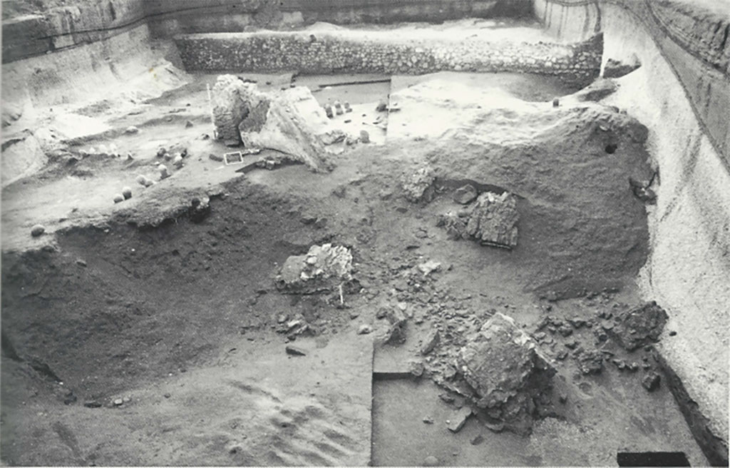
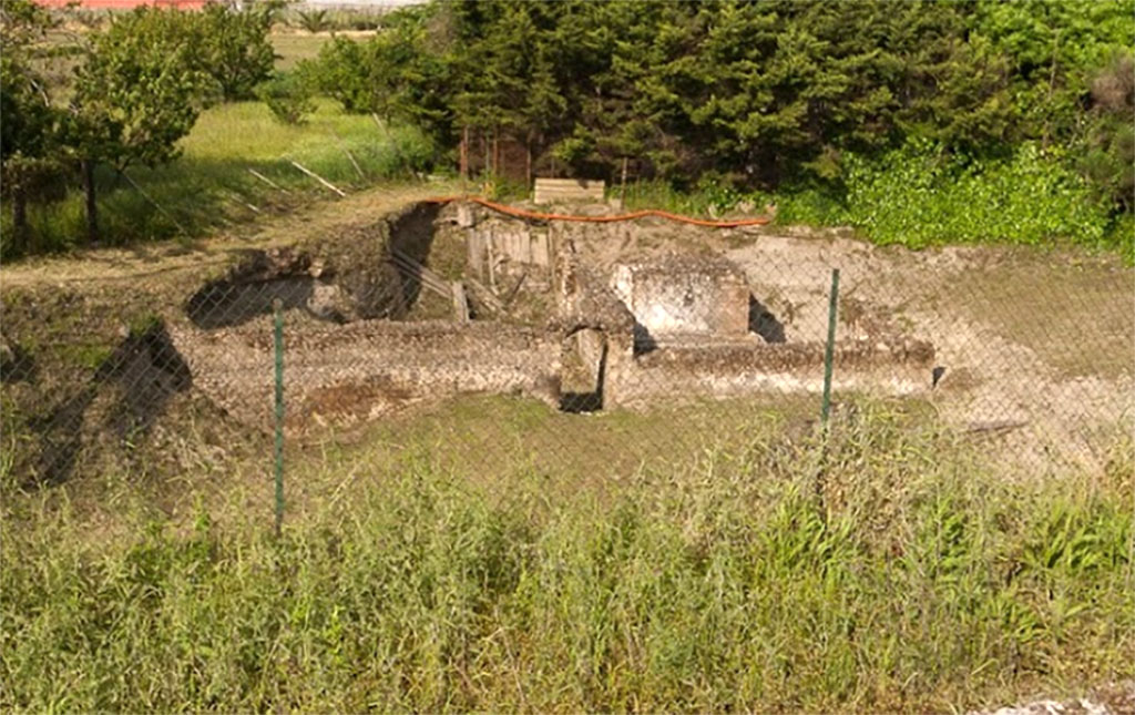
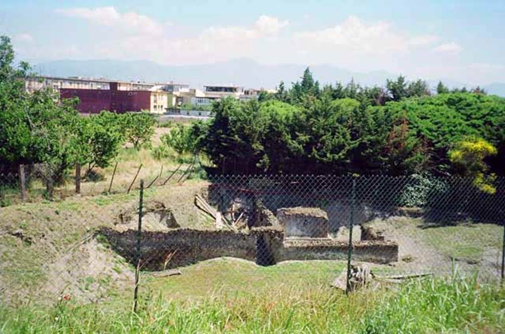
Pompeii Porta
Sarno Necropolis. 1998. Necropoli romana presso via Nolana. Area dello scavo.
Roman necropolis
near via Nolana. Area of excavations.
See D'Ambrosio A.
Scavi e Scoperte nel suburbio di Pompei. Rivista di studi Pompeiani IX,
1998, p. 197, fig. 1.
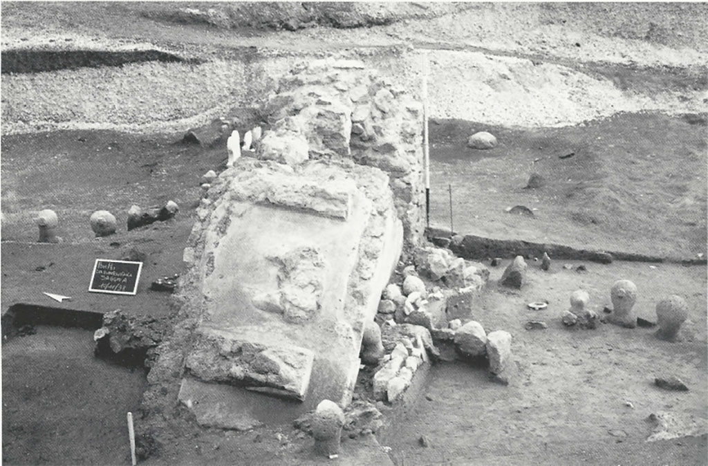
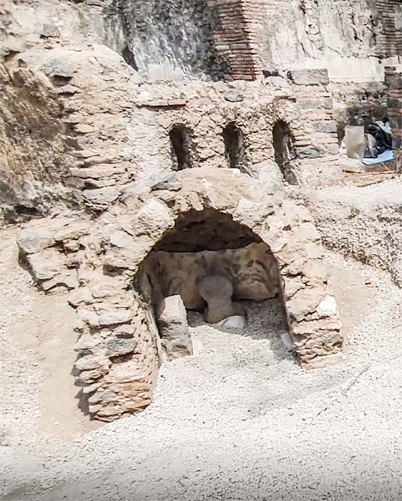
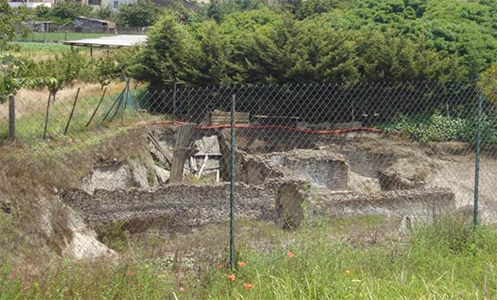
Pompeii Porta
Sarno Necropolis. 1998. Necropoli romana presso via Nolana. Il monumento
funerario in crollo. Nell'area sepolcrale spicca un grande podio, in opera
incerta intonacata su tutti i lati, sulla cui faccia superiore, delimitata da
sponde modanate, resta traccia della parte inferiore di una statua di grandi
dimensioni. In particolare, si riconosce la parte anteriore dei calzari e, sul
lato posteriore, l'appoggio del bordo di una lunga tunica.
Roman necropolis near via Nolana. Collapsed funerary monument. In the burial area stands a large podium, in opus incerta work plastered on all sides, on whose upper face, bordered by moulded sides, remains traces of the lower part of a large statue. In particular, the front of the shoes and the back of the edge of a long tunic can be recognized.
See D'Ambrosio A.
Scavi e Scoperte nel suburbio di Pompei. Rivista di studi Pompeiani IX,
1998, p. 198, fig. 2.
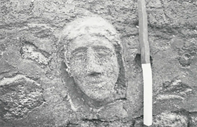
Pompeii Porta
Sarno Necropolis. 1998. Necropoli romana presso via Nolana. Testa in tufo di
statua funeraria.
Roman necropolis near via Nolana. Tufa head of funerary statue.
See D'Ambrosio A.
Scavi e Scoperte nel suburbio di Pompei. Rivista di studi Pompeiani IX,
1998, p. 198, fig. 3.
1999
Suburbio Orientale in Rivista di Studi Pompeiani X, 1999, p.
180-182
È proseguito, fino a giugno 1999, lo scavo nell'area ad
est della Circumvesuviana, in corrispondenza dell'Anfiteatro. del quale si è
già data notizia nel precedente numero di questa rivista. Sono state messe in
luce altre sepolture a cremazione di età romana. simili a quelle già note e in
una situazione stratigrafica analoga a quella cui si è già accennato nello
scorso Notiziario: ora, complessivamente. sono circa 80.
Circostanze contingenti, in particolare esigenze di
tutela, hanno indotto ad approfondire subito lo scavo, al di sotto degli strati
di frequentazione romana, in alcuni punti dell'area ove erano state individuate
sepolture più antiche. Sono state, così, messe in luce 3
tombe ad inumazione di età sannitica, due a cassa di blocchi di travertino ed
una a fossa ma anch'essa con copertura di blocchi di travertino. In
quest'ultima, erano due deposizioni successive, entrambe con scheletri
orientati nord-sud, con cranio a sud. La deposizione più antica recava a
corredo una lekythos a reticolo; quella successiva era priva di corredo. Le due
tombe a cassa sono, invece, orientate est-ovest. Anche in una di esse erano due
scheletri, deposti in momenti successivi, con testa ad ovest; presso quello più
recente erano 4 unguentari fittili ellenistici. La prima tomba esplorata conteneva un solo scheletro con
testa ad ovest (fig. I). Presso i piedi era il corredo, costituito da un'olla
acroma. una kylix a vernice nera, con stampigliatura a 6 rosette congiunte da archi di cerchio, una oinochoe a vernice
nera. con bocca rotonda. Sono, come si vede, sepolture povere databili tra la
metà del IV e gli inizi del sec. III a. C. Il cantiere di scavo è stato
diretto. sotto la sorveglianza e la supervisione della Soprintendenza, dalla
dott.ssa Laura Maggio.
Un secondo cantiere è stato aperto nell'area esterna alla
c.d. Porta Sarno anche in questo caso con fruttuosi risultati. Oltre al
prosieguo fuori città di via dell'Abbondanza, è stato messo in luce un altro
asse viario che si distacca da quello suddetto e prosegue verso NO-SE, in direzione
delle mura di cinta, anch'esso lastricato con basoli per gran parte del tratto
scavato. È stata, inoltre, scoperta una nuova area di necropoli nella quale è
da segnalare, in particolare, un grande monumento funerario (fig. 2) - del tipo
"a dado" su podio - del quale, purtroppo è andata perduta la parte
superiore e con essa l'epigrafe che, verosimilmente, doveva esserci, così che
ne resta sconosciuto il proprietario. L'edificio, in opera incerta, con
ammorsature angolari in opera laterizia, rivestito di intonaco bianco, è
inserito in un recinto in opera incerta, nel quale si aprono strette afinestrature
verticali. Alla base del lato posteriore, si apre una nicchia, a sua volta
contenente una nicchia più piccola nella quale era posta, infissa nel terreno,
una columella con il cinerario relativo. Nello spazio tra il recinto e il
podio, sono state evidenziate cavità pertinenti alle radici di alberi,
probabilmente cipressi, che circondavano il monumento.
Pochi metri a sud-ovest dell'edificio funerario descritto
sono affiancati due piccoli basamenti (fig. 3) in opera incerta ricoperta di
intonaco rosso, uno dei quali decorato con motivi geometrici suddipinti, nella sommità dei quali era infissa una lastra
in marmo bianco con epigrafe. Quasi completamente illeggibile una delle due,
meglio conservata l'altra che menziona un Lucius Mettius Martialis, militare
originario della città siriana di Carre, morto a 30 anni dopo 10 anni di
servizio come speculator:
L. METTIVS
M F POLL
MARTIALIS
CARR
SPECVL
MIL AN X VIX AN XXX.
A nord-ovest del recinto funerario, a questo adiacente, è
stata parzialmente esplorata un'area con strutture, caratterizzata da un
colonnato in opera vittata mista con laterizi e blocchetti di pietra lavica e
di travertino. Lo stato delle strutture e l'accumulo, nello stesso luogo, di blocchi
di pietra lavica non ancora sbozzati, lascia pensare che fossero ancora in
corso lavori di costruzione o di rifacimento. Nella scarpata che delimita
questo settore sul lato N, è chiaramente visibile, in sezione, una grande fossa
imbutiforme (profonda 2,80 m; larga 2, 70 m alla sommità e 1.50 m alla base)
che taglia nettamente la stratigrafia eruttiva. Alla base, c'è un deposito di
ossa umane e alcune animali (fig. 4), apparentemente in giacitura secondaria dal
momento che non sono in connessione. Sotto questo cumulo di ossa, sono alcuni
vasi fittili, anch'essi contenenti ossa combuste. Questo accumulo di reperti,
così come le strutture murarie cui si è fatto cenno, ambedue di poco chiara
interpretazione. proseguono sotto la scarpata che delimita lo scavo. Si spera
che un ampliamento dell'area di intervento e un approfondimento
dell'esplorazione possano chiarire la situazione.
Il cantiere di scavo è stato diretto, sotto la
sorveglianza e la supervisione della Soprintendenza, dalla dott.ssa Maria Lucia
Cinquepalmi.
A. D' AMBROSIO
Vedi Suburbio
Orientale in Rivista di Studi Pompeiani X, 1999, p. 180-182.
Our
approximate translation:
Excavation continued until June 1999 in
the area east of the Circumvesuviana, in correspondence with the Amphitheatre. which has already been reported in the
previous issue of this magazine. Other cremation burials from the Roman age have been brought to
light. similar to those
already known and in a stratigraphic situation similar to the one already
mentioned in the last Newsletter: now, overall. they are about 80.
Contingent
circumstances, in particular protection requirements, led to the immediate
deepening of the excavation, below the layers of Roman occupation, in some
points of the area where more ancient burials had been identified. As a result,
three inhumation tombs from the Samnite period were brought to light, two with
a casket of travertine blocks and one with a pit, but also covered by
travertine blocks. In the latter, there were two successive depositions, both
with skeletons oriented north south, with the skull to the south. The older
burial contained a reticulated lekythos; the later one was without grave goods.
The two travertine lined tombs, on the other hand, are oriented east-west. In
one of them there were also two skeletons, laid down at separate times, with
the head facing west; near the most recent one there were four Hellenistic clay
ointment/perfume jars. The first tomb explored contained a single skeleton with
the head to the west (Fig. I). At the foot was the grave goods, consisting of
an achromatic olla. a black-painted kylix, with 6 rosettes joined by circular
arches, a black-painted oinochoe. with a round mouth. These are, as can be
seen, poor burials datable between the middle of the 4th and the beginning of
the 1st century BC. C. The excavation site was directed under the supervision
of the Soprintendenza by Dr Laura Maggio.
The two
chest tombs, on the other hand, are oriented east-west. Also in one of them
were two skeletons, deposited in successive moments, with their heads to the
west; in the more recent one there were 4 Hellenistic clay ointments. The first
tomb explored contained a single skeleton with a western head (fig. I). At the
feet was the trousseau, consisting of an achromatic olla. a black varnished
kylix, stamped with 6 rosettes joined by circular arcs, a black varnished
oinochoe. with round mouth. They are, as can be seen, poor burials dating back
to between the mid-4th and the beginning of the 3rd century BC. The excavation
site was directed under the supervision and oversight of the Superintendency,
by Dr Laura Maggio.
A second
site was opened in the area outside the so-called Porta Sarno also in this case
with fruitful results. In addition to the continuation outside the city of via
dell'Abbondanza, another road axis has been unearthed that detaches itself from
the aforementioned one and continues towards NW-SE, in the direction of the
surrounding walls, also paved with paving stones for most of the tract
excavated. A new necropolis area was also discovered in which, in particular, a
large funerary monument (fig. 2) - of the "a dado" type on a podium -
of which, unfortunately, the upper part has been lost with it the epigraph that
probably must have been there, so that the owner remains unknown. The building,
in opus incerta, with corner brackets in brick work, covered with white
plaster, is inserted in an enclosure in opus incerta work, in which narrow
vertical windows open. At the base of the rear side, there is a niche, in turn
containing a smaller niche in which a columella with the related cinerary
material was placed, stuck in the ground. In the space between the enclosure
and the podium, cavities relevant to the roots of trees, probably cypresses,
that surrounded the monument were highlighted.
L. METTIVS M F POLL
MARTIALIS CARR
SPECVL MIL AN X VIX AN XXX.
To the
north-west of the funerary enclosure, adjacent to it, an area with structures
has been partially explored, characterised by a colonnade in opus vittata mixed
with bricks and blocks of lava stone and travertine. The state of the
structures and the accumulation, in the same place, of blocks of lava stone
that had not yet been hewn, suggest that construction or reconstruction work
was still in progress. In the escarpment that delimits this sector on the N
side, a large funnel-shaped pit (2.80 m deep, 2.70 m wide at the top and 1.50 m
wide at the base) is clearly visible in section, clearly cutting through the
eruptive stratigraphy. At the base, there is a deposit of human and a few
animal bones (Fig. 4), apparently in a secondary position since they are not
connected. Beneath this pile of bones, are a few clay pots, also containing
burnt bones. This accumulation of artefacts, as well as the wall structures
mentioned above, both of which are of unclear interpretation, continue under
the slope that delimits the excavation. It is hoped that an extension of the
intervention area and further exploration will clarify the situation.
The
excavation site was directed under the supervision of the Superintendency by Dr
Maria Lucia Cinquepalmi.
A. D' AMBROSIO
See Suburbio
Orientale in Rivista di Studi Pompeiani X, 1999, p. 180-182.
2015
The Tombs of Pompeii: Organization, Space and Society p. 337
According to Virginia Campbell, excavations carried out in 1999 as part of the expansion of the Circumvesuviana revealed a collection of more than eighty graves, ranging from urns containing cremated remains often marked with a lava columella to simple holes.
Four marble columellae were also recovered, one of which bore the inscription:
Curtia Phyle
v(ixit) a(nnis) XXX.
Curtia Phyle lived for 30 years.
See Rivista di Studi Pompeani, 9, 1998, p. 197 (A. D'Ambrosio) - AE 2013
(1)
Further excavation revealed three Samnite graves dating from the mid fourth to early third centuries BC.
Subsequently some exploration was done beyond the Porta di Sarno, where a funerary monument consisting of a large podium with no surviving superstructure or inscription was discovered. One columella marking an urn was found at the base of the rear of the podium. The tomb is surrounded by a wall of opus incertum, and root cavities suggest trees, likely cypress, were planted between the wall and the tomb.
A few meters south-east of the tomb, there are two pillars of opus incertum, on the top of which was stuck a marble slab with inscriptions, one illegible, the other contained the text:
L(ucius) Mettius
M{arci) f(ilius) Poll(a tribu) /
Martialis Carr(?)
/
specul(ator)
mil(itavit) an(nos) X vix(it) an(nos) XXX.
Lucius Mettius Martialis, son of Marcus, member of the Pollan tribe, from Carre, speculator, served in the military for ten years, lived for thirty years.
See Campbell V. L., 2015. The Tombs of Pompeii: Organization, Space and Society. Oxford: Routledge, p. 337.
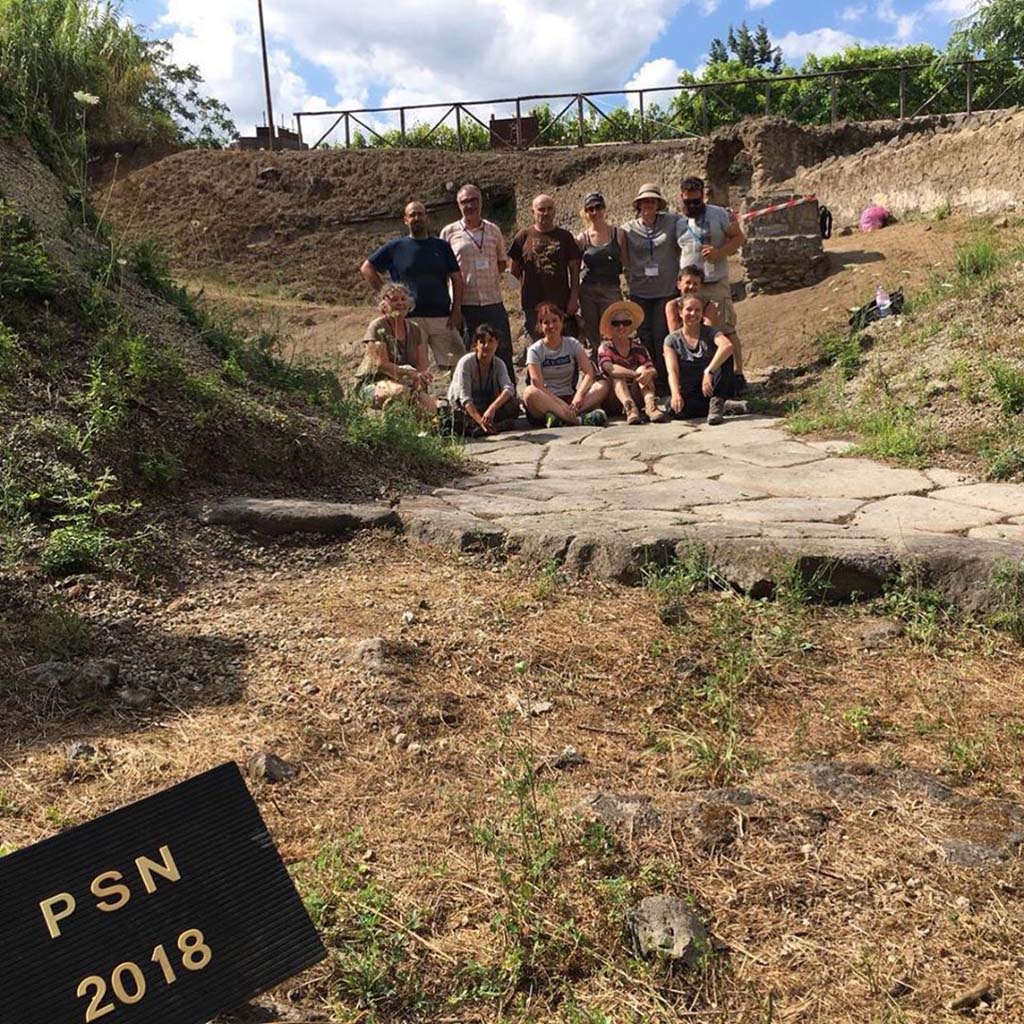
2018
From the Parco Archeologico di Pompei press releases
[PAP August 2018] At the necropolis of Porta Sarno, on the other hand, during an emergency excavation in 1998-99, some Samnite tombs and two Roman funerary enclosures were discovered. This summer began the first campaign of the scientific study and investigation project, object of the agreement with the Colegio de Doctores y Licenciados de Valencia, the Universidad Europea de Valencia and the Institut Valencià de restauració I Conservació under the direction of R. Albiach and L. Alapont, aimed at the restoration of the funerary monuments and the photogrammetric and planimetric documentation of the necropolis.
[PAP Agosto 2018] Presso la necropoli di Porta Sarno,
invece, durante uno scavo di emergenza del 1998-99 furono scoperte alcune tombe
sannitiche e due recinti funerari romani. Quest’estate si è avviata la prima
campagna del progetto di studio e indagine scientifica, oggetto della
convenzione con il Colegio de Doctores y Licenciados de
Valencia, la Universidad Europea de Valencia e
l’Institut Valencià de restauració
I Conservació sotto la direzione di R. Albiach e L.
Alapont, finalizzata al restauro dei monumenti funerari e alla documentazione
fotogrammetrica e planimetrica della necropoli.
See http://pompeiisites.org/comunicati/nuovi-scavi-e-ricerche-a-pompei-2/
Necropoli di Porta Sarno Project Summary Report 2018
The works planned and carried out in the area of the Porta
Sarno necropolis out during this first phase of the 2018 campaign, were the
following:
1.-Evaluation of the State of Conservation
We note that since the excavation concluded in early 1999, it had been
highly affected by environmental and anthropic factors.
There were frequent visits to the area demonstrated by waste
material such as glass bottles, plastic and cans. on the surface and covered by
the lapilli fallen from the stratigraphic cuts.
There were some architectural fragments on the curb of the via dell’ Abbondanza that had fallen from its original position, as well as an archaic capital that was on the secondary road. The stuccos of the funerary monuments and the rest of the structures had collapsed almost totally in these 19 years. In the press images it is seen that both the tombs of the praetorians and the funerary monument “a dado” on the podium were completely covered.
Much of the effort of this first has thus been invested in stopping this
deterioration and preventing future collapse, which will be explained in the
corresponding section, No. 5.
The stratigraphic sections of the excavation, formed by the lava levels that
covered the city of Pompeii and the Vesuvian area in 79 AD, were once sheltered
with rods, red plastic mesh and wooden planks to protect this fragile material
against the inclemencies of the weather and the
vibrations produced by the frequent passage of the Circumvesuviana train, but
over the years these were collapsing in successive landslides.
Vegetation had also invaded numerous areas that had been cleared from it a few months before as well as on other occasions.
2.- Cleaning and Preparation Work for Future
Interventions
On July 10, 2018, we began the cleaning and documentation of the
necropolis, focusing, above all, on the structures affected by the degradation
and with restoration needs as well as in the areas considered as priorities for
future excavation work. The areas that were most widely cleaned were the
following:
• Main road, via dell’Abbondanza, and the secondary road to the city bypass
• Funerary site with a monument “a dado” on a podium
• Funerary site with a collapsed monument “a colonnella”
• Two tombs of praetorians
• Possible Samnite area next to the secondary road.
Special attention has been devoted to the cleaning of plants and moss that had
grown on the walls, both to stop their deterioration and to be able to carry
out the consolidation work and the 3D imaging of the structures.
Zone E was also cleaned from the funerary enclosure with monument “a dado” and
it was seen that in zone N there is a wall – UE 1040 – that would have been
part of another enclosure located towards the northern area of the excavation
that would be already inside the cut stratigraphic Also in zone E, but in part
S, there is another small monument similar to the ones near the Praetorians –
EU 1039.
The lapilli that were removed during the cleaning process
was left in the area that we agreed at the March meeting, to the NO of the
excavation area.
Numerous general and detailed photographs of the excavation
were made as well as all the structures and stratigraphic levels, before,
during and at the end of the cleaning process.
The work concluded with covering with geotextile of the areas that were wanted to preserve in optimal conditions so that at the moment of beginning the excavation in 2019 they are in perfect condition and the work is not slowed down. These areas have been the following:
• Interior of the funerary enclosure that has the “a dado”
monument on the podium
• Interior of the funerary site that has the collapsed “colonnato” monument
• Outside area of the funeral precincts next to the tombs of the praetorians
• Continuation of the pavement or rudus of pebbles and stones
Study and Documentation of the Walls
The space of the intervention was divided into different work zones, where the
two funerary enclosures known to date in the necropolis stand out: – AREA A:
Funerary site with a monument on podium. – AREA B: Funerary site with a
monument of type “colonnato”.
The area outside these enclosures was also subdivided into several areas: –
AREA C: Samnite necropolis. – AREA D: area east of site A. – AREA E: via dell’Abbondanza,
E-OE direction. – AREA F: auxiliary road, N-S direction. – AREA G: Funerary
monument south of the auxiliary road. – AREA H: Praetorian tombs area. – AREA
J: space between the funeral precincts and the area of the Samnite necropolis.
– AREA K: space between the two tracks.
As we have already said, the field work consisted solely in the clean-up and
preparation of the site, focusing on the structures and above all on stopping
the deterioration suffered by these since its discovery in 1998.
Therefore, the work at the level of sediments has consisted in the surface
cleaning of the different areas where it is expected to work next year, until
reaching the levels at which the excavation ended in 1998, removing the lapilli
fallen from the cuts, in these last years, and the vegetation that covered the
deposit, very abundant, in some areas.
Summary Author:
Llorenç Alapont
(Ilustre Colegio Oficial de Doctores y Licenciados en Filosofía, Letras y
Ciencias de Valencia y Castellón, Universidad Europea de Valencia)
See FastiOnline Necropoli di Porta Sarno 2018 Use subject to CC BY-SA 4.0
2019
The 2019 excavation season will focus on two specific areas. The first
area is in front of the walls of the façade of the funeral enclosures (Area J
in pink on the plan above). This area was first brought to light during the
preventive excavation campaign of the Porta Sarno Necropolis in 1998 (A.
d'Ambrosio, Studi Pompeiani IX, 1998. L'Erma, Rome, 2000, pp. 195-198. [12: 23,
5/2/2018]). The presence of Samnite levels and specifically one Samnite tomb
with goods is mentioned. The project’s objective in this area is to complete
the excavation and study the layers and structures previously and partially
excavated in order to confirm the Samnite levels of use on the site and to
conduct a further investigation that seeks to verify the presence of other
Samnite tombs belonging to an anterior burial necropolis.
Pompeii archaeology of death project at porta sarno 2019
2020
The 2020 excavation season will focus on two specific areas. The first
area is located in front of the walls of the façade of the funeral enclosures
(Area J). This area was first brought to light during the preventive excavation
campaign of the Porta Sarno Necropolis in 1998. The presence of Samnite levels
and specifically one Samnite tomb with goods is mentioned. The project’s
objective in this area is to complete the excavation and study the layers and
structures partially excavated in order to confirm the Samnite levels of use on
the site and to conduct a further investigation that seeks to verify the
presence of other Samnite tombs belonging to an anterior burial necropolis. The
second and third areas are located north (Area B) and south (Area D) of the
enclosure with funerary podium monument. The last year we completed the
excavation and study of the partially excavated layers and structures,
confirming the presence of cremations and locating and excavating them inside
the funerary enclosure. By excavating them in this way, we will document the
organization of the funerary enclosure and verify the stratigraphic sequence in
order to prove the existence of multiple levels of use and occupation in the
necropolis.
Pompeii archaeology of death project at porta sarno 2020
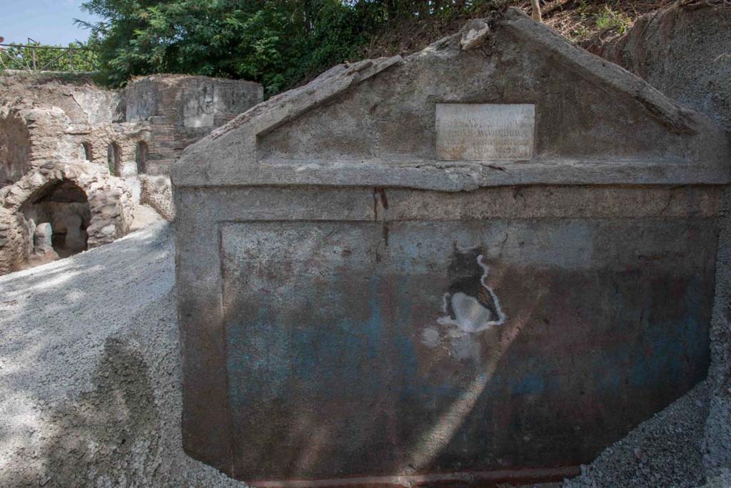
17 AUGUST 2021
The tomb of Marcus
Venerius Secundio has been discovered at Porta Sarno with mummified human
remains
Mummified
remains, along with the hair and bones of an individual buried in an ancient
tomb have been found at the necropolis of Porta Sarno, to the east of the
ancient urban centre of Pompeii. On a marble slab
located on the pediment of the tomb, a commemorative inscription to the owner
Marcus Venerius Secundio makes
reference,
extraordinarily, to performances at Pompeii that were conducted in Greek,
direct evidence of which has never before been found. This is the latest
discovery at Pompeii, which took place during an excavation campaign carried
out in the Porta Sarno Necropolis area, on the initiative of the Archaeological
Park of Pompeii and the European University of Valencia.
The tomb
structure, which dates to the final decades in the life of the city, consists
of a masonry enclosure, with traces of paint preserved on the facade: it is
possible to distinguish green plants on a blue background. The figure of Marcus
Venerius Secundio - who also appears in the wax tablet archive of the Pompeian
banker Caecilius Giocondo, owner of the domus of the same name on Via Vesuvio -
was a public slave and custodian of the Temple of Venus. Upon being freed, he
reached a certain social and economic status, as can be understood from the
rather monumental tomb, and the inscription: in addition to joining the ranks
of the Augustales, or the college of priests dedicated to the Imperial Cult, as
the epigraph recalls he "gave Greek and Latin ludi for the duration of
four days". "Ludi graeci are to be
understood as performances in the Greek language': - observes the Director of the
Archaeological Park of Pompeii, Gabriel Zuchtriegel.
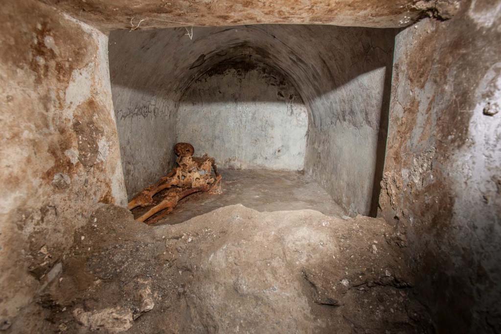
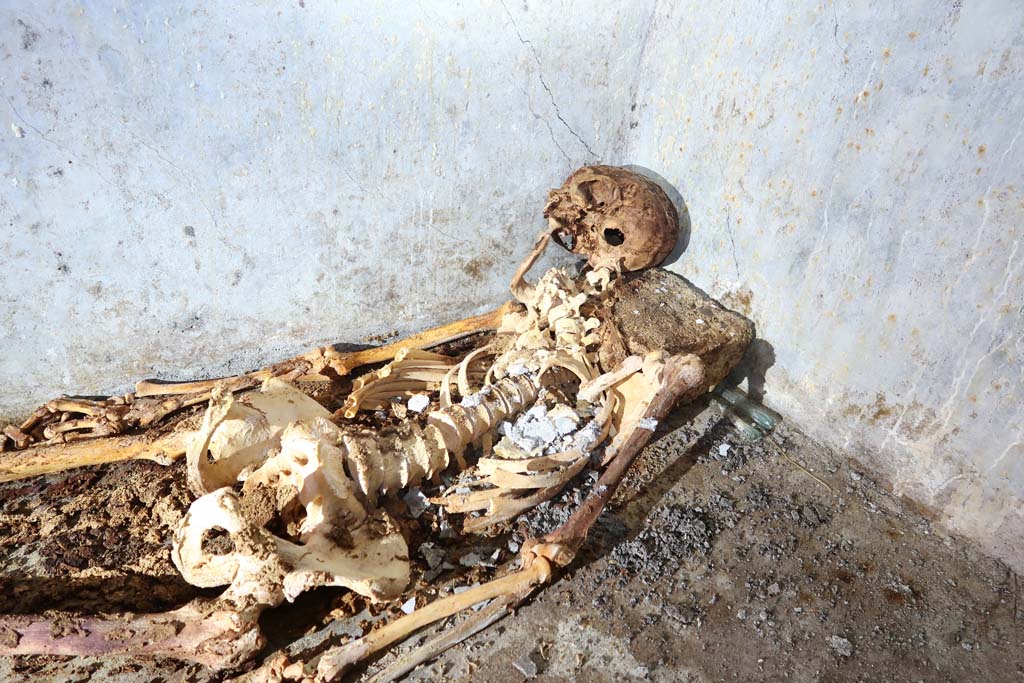
No less
exceptional than the inscription is the burial of Marcus Venerius Secundio,
with one of the best-preserved skeletons ever found in the ancient city. The
deceased was buried in a small cell of 1.6 x 2.4 metres, located behind the
main facade, while in the remaining part of the enclosure evidence of cremation
has been found, in the form of two cinerary urns, one of which is a beautiful glass
container belonging to a woman by the name of Novia Amabilis. During the Roman
period at Pompeii, funeral rites usually involved cremation, while only small
children were buried. The burial of Marcus Venerius is thus highly unusual also
for the funeral rite that was adopted, considering that he was an adult man
over 60 years of age, as evidence emerging from the initial analysis of bones
found in the burial chamber indicates. The characteristics of the funerary chamber,
which consisted of a hermetically sealed room, created conditions that allowed
for the exceptional state of preservation in which the skeleton was found, with
hair and an ear still visible. Furthermore, grave goods have been recovered,
including two glass unguentaria and numerous fragments of what appears to be
fabric. "We still need to understand whether the partial mummification of
the deceased is due to intentional treatment or not" - explains Professor Llorenc Alapont of the University of Valencia -
"analysis of the fabric could provide further information on this".
Rinvenuta a Porta Sarno la tomba di Marcus Venerius
Secundio con resti umani mummificati
Resti umani mummificati, capelli e ossa di un individuo
inumato in una antica sepoltura, rinvenuta presso la necropoli di Porta Sarno,
a est dell'antico centro urbano di Pompei. Sulla lastra marmorea posta sul
frontone della tomba un'iscrizione commemorativa del proprietario Marcus
Venerius Secundio richiama, straordinariamente, lo svolgimento a Pompei di
spettacoli in lingua greca, mai prima attestati in maniera diretta. Si tratta
dell'ultima scoperta di Pompei, avvenuta nel corso di una campagna di scavo promossa
nell'area della necropoli di Porta Sarno, dal Parco Archeologico di Pompei e
dall'Università Europea di Valencia.
La struttura sepolcrale, risalente agli ultimi decenni di
vita della città, è costituita da un recinto in muratura, sulla cui facciata si
conservano tracce di pittura: si intravedono piante verdi su sfondo blu. Il
personaggio di Marcus Venerius Secundio - che compare anche nell'archivio di
tavolette cerate del banchiere pompeiano Cecilio Giocondo, proprietario della
domus omonima su via Vesuvio – era uno schiavo pubblico e custode del tempio di
Venere. Una volta liberato, aveva poi raggiunto un certo status sociale ed
economico, come emergerebbe non solo dalla tomba piuttosto monumentale, ma
anche dall'iscrizione: oltre a diventare Augustale, ovvero membro del collegio
di sacerdoti dediti al culto imperiale, come ricorda l'epigrafe, "diede
ludi greci e latini per la durata di quattro giorni". "Ludi graeci è da intendere come spettacoli in lingua greca -
commenta il direttore del Parco archeologico di Pompei, Gabriel Zuchtriegel.
Non meno eccezionale dell'iscrizione risulta
la sepoltura di Marco Venerio Secundio. Si tratta di uno degli scheletri meglio
conservati ritrovati nella città antica. Il defunto fu inumato in una piccola
cella di 1,6 x 2,4 metri posta alle spalle della facciata principale,
mentre nella restante parte del recinto sono state riscontrate due
incinerazioni in urna, una in un bellissimo contenitore in vetro appartenente a
una donna di nome Novia Amabilis. La sepoltura di Marco Venerio è dunque
altamente insolita anche per il rito funerario adottato, considerando che si
trattava di un uomo adulto di più di 60 anni, come emerge da una prima analisi
delle ossa ritrovate nella camera funeraria. Le caratteristiche della camera
funeraria, che consisteva in un ambiente ermeticamente
chiuso, hanno creato le condizioni per lo stato di conservazione
eccezionale in cui è stato trovato lo scheletro, con capelli e un orecchio
ancora visibili. Inoltre, sono stati recuperati elementi di corredo, tra cui
due unguentaria in vetro e numerosi frammenti di ciò che sembra essere un
tessuto. "Bisogna ancora comprendere se la mummificazione parziale del
defunto è dovuta a un trattamento intenzionale o meno - spiega il professor
Llorenç Alapont dell'Università di Valencia - In questo l'analisi del tessuto
potrebbe fornire ulteriori informazioni.
Porta Sarno la tomba di Marcus Venerius Secundio. August 2021. Looking south-east to
new tomb opposite road area E.
A hermetically
sealed burial chamber can be seen at the front of the tomb. Tomb areas B and A are in the foreground.
Guardando verso sud-est alla nuova tomba di fronte all'area stradale E.
Un ambiente ermeticamente chiuso può essere visto nella parte anteriore
della tomba. Le aree tombali B e A sono in primo piano.
Photograph ©
Parco Archeologico di Pompei.
Porta Sarno la tomba di Marcus Venerius Secundio. August 2021. Front of tomb with
inscribed commemorative plaque.
The tomb
structure, which dates to the final decades in the life of the city, consists
of a masonry enclosure, with traces of paint preserved on the façade.
It is
possible to distinguish green plants on a blue background.
Frontone della tomba con lastra marmorea con iscrizione
commemorativa.
La struttura sepolcrale, risalente agli ultimi decenni di
vita della città, è costituita da un recinto in muratura, sulla cui facciata si
conservano tracce di pittura.
Si intravedono piante verdi su sfondo blu.
Photograph ©
Parco Archeologico di Pompei.
Porta Sarno la tomba di Marcus Venerius Secundio. August
2021.
On a marble
slab located on the pediment of the tomb, a commemorative inscription to the
owner Marcus Venerius Secundio makes reference,
extraordinarily, to performances at Pompeii that were conducted in Greek,
direct evidence of which has never before been found.
The figure
of Marcus Venerius Secundio - who also appears in the wax tablet archive of the
Pompeian banker Caecilius Giocondo, owner of the domus of the same name on Via
Vesuvio - was a public slave and custodian of the Temple of Venus. Upon being
freed, he reached a certain social and economic status, as can be understood
from the rather monumental tomb, and the inscription: in addition to joining
the ranks of the Augustales, or the college of priests dedicated to the
Imperial Cult, as the epigraph recalls he "gave Greek and Latin ludi for
the duration of four days". "Ludi graeci
are to be understood as performances in the Greek language': - observes the
Director of the Archaeological Park of Pompeii, Gabriel Zuchtriegel.
Sulla lastra marmorea posta sul frontone della tomba
un'iscrizione commemorativa del proprietario Marcus Venerius Secundio richiama,
straordinariamente, lo svolgimento a Pompei di spettacoli in lingua greca, mai
prima attestati in maniera diretta.
Il personaggio di Marcus Venerius Secundio - che compare
anche nell'archivio di tavolette cerate del banchiere pompeiano Cecilio
Giocondo, proprietario della domus omonima su via Vesuvio – era uno schiavo
pubblico e custode del tempio di Venere. Una volta liberato, aveva poi
raggiunto un certo status sociale ed economico, come emergerebbe non solo dalla
tomba piuttosto monumentale, ma anche dall'iscrizione: oltre a diventare
Augustale, ovvero membro del collegio di sacerdoti dediti al culto imperiale, come
ricorda l'epigrafe, "diede ludi greci e latini per la durata di quattro
giorni". "Ludi graeci è da intendere come
spettacoli in lingua greca - commenta il direttore del Parco archeologico di
Pompei, Gabriel Zuchtriegel.
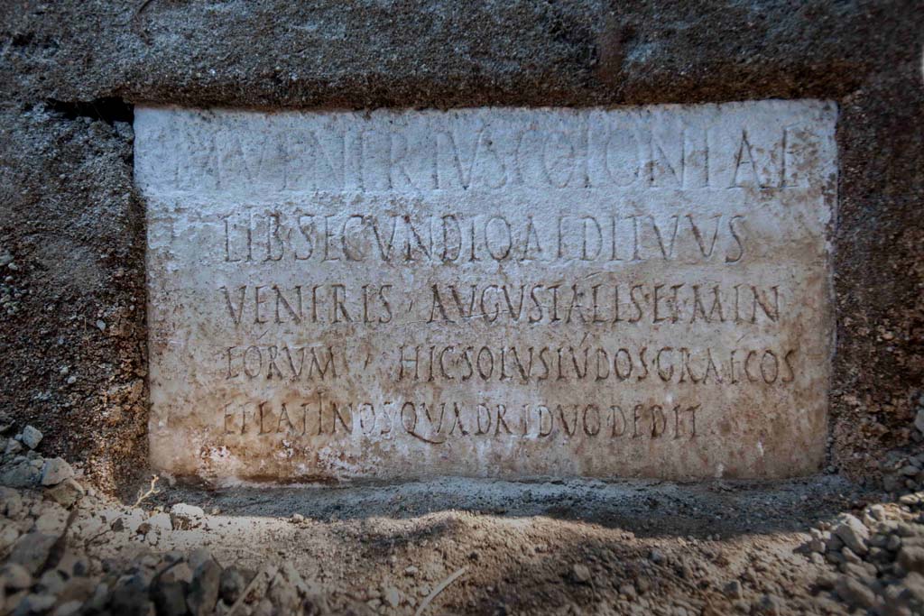
M
VENERIVS COLONIAE
LIB
SECUNDIO AEDITVVS
VENERIS
AVGVSTALIS ET MIN
EORVM HIC SOLVS
LVDOS GRAECOS
ET LATINOS
QVADRIDVO DEDIT
Photograph ©
Parco Archeologico di Pompei.
According
to Virginia Campbell the reads as:
M(arcus) Venerius
coloniae
lib(ertus) Secundio, aedituus
Veneris, Augustalis et min(ister)
eorum. Hic solus ludos Graecos
et Latinos quadriduo dedit.
And translates as:
‘Marcus Venerius Secundio, freedmen of the colony, guardian of the temple of Venus, Augustalis and minister of them. He, on his own, gave Greek and Latin games for four days.
See https://pompeiinetworks.wordpress.com/2021/08/19/the-tomb-of-marcus-venerius-secundio/
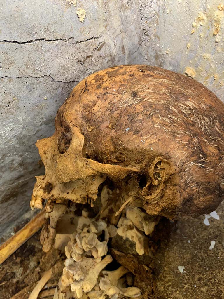
Porta Sarno la tomba di Marcus Venerius Secundio. August 2021. Mummified skeleton in
hermetically sealed inner chamber.
No less
exceptional than the inscription is the burial of Marcus Venerius Secundio,
with one of the best-preserved skeletons ever found in the ancient city.
The
deceased was buried in a small cell of 1.6 x 2.4 metres, located behind the
main façade
Scheletro mummificato in un ambiente ermeticamente chiuso.
Non meno eccezionale dell'iscrizione risulta la sepoltura
di Marco Venerio Secundio.
Si tratta di uno degli scheletri meglio conservati
ritrovati nella città antica.
Il defunto fu inumato in una piccola cella di 1,6 x 2,4
metri posta alle spalle della facciata principale.
Photograph ©
Parco Archeologico di Pompei.
Porta Sarno la tomba di Marcus Venerius Secundio. August 2021. One of the
best-preserved skeletons ever found in the ancient city.
During the
Roman period at Pompeii, funeral rites usually involved cremation, while only
small children were buried. The burial of Marcus Venerius is thus highly
unusual also for the funeral rite that was adopted, considering that he was an
adult man over 60 years of age, as evidence emerging from the initial analysis
of bones found in the burial chamber indicates. The characteristics of the
funerary chamber, which consisted of a hermetically sealed room, created
conditions that allowed for the exceptional state of preservation in which the
skeleton was found, with hair and an ear still visible.
Uno degli scheletri meglio conservati ritrovati nella
città antica.
Durante il periodo romano a Pompei, i riti funebri di
solito prevedevano la cremazione, mentre solo i bambini piccoli venivano
sepolti. La sepoltura di Marco Venerio è dunque altamente insolita anche per il
rito funerario adottato, considerando che si trattava di un uomo adulto di più
di 60 anni, come emerge da una prima analisi delle ossa ritrovate nella camera
funeraria. Le caratteristiche della camera funeraria, che consisteva in un ambiente
ermeticamente chiuso, hanno creato le condizioni per lo stato di conservazione
eccezionale in cui è stato trovato lo scheletro, con capelli e un orecchio
ancora visibili.
Photograph ©
Parco Archeologico di Pompei.
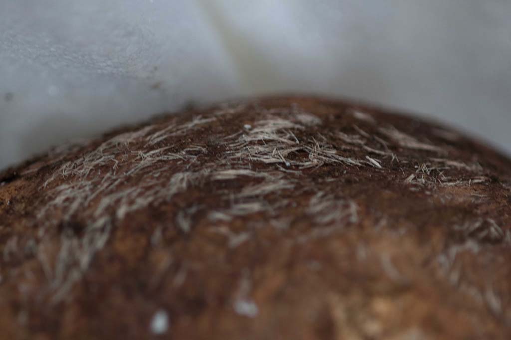
Porta Sarno la tomba di Marcus Venerius Secundio. August 2021. Skull of skeleton
showing remains of hair.
Cranio di scheletro che mostra resti di capelli.
Photograph ©
Parco Archeologico di Pompei.
Porta Sarno la tomba di Marcus Venerius Secundio. August 2021. Hair on top of skull.
Capelli sopra il cranio.
Photograph ©
Parco Archeologico di Pompei.
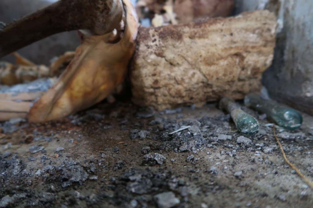
Porta Sarno la tomba di Marcus Venerius Secundio. August 2021. Two glass unguentaria.
Grave
goods have been recovered, including two glass unguentaria and numerous fragments
of what appears to be fabric.
"We
still need to understand whether the partial mummification of the deceased is
due to intentional treatment or not" - explains Professor Llorenc Alapont of the University of Valencia -
"analysis of the fabric could provide further information on this".
Due unguentaria in vetro.
Sono stati recuperati elementi di corredo, tra cui due
unguentaria in vetro e numerosi frammenti di ciò che sembra essere un tessuto.
"Bisogna ancora comprendere se la mummificazione parziale del defunto è
dovuta a un trattamento intenzionale o meno - spiega il professor Llorenç
Alapont dell'Università di Valencia - In questo l'analisi del tessuto potrebbe
fornire ulteriori informazioni.
Photograph ©
Parco Archeologico di Pompei.
Porta Sarno la tomba di Marcus Venerius
Secundio. August 2021. Looking past the front
of the tomb to small arched tomb with two cippi.
Guardando oltre la parte anteriore della tomba fino alla piccola tomba ad
arco con due cippi.
Photograph ©
Parco Archeologico di Pompei.
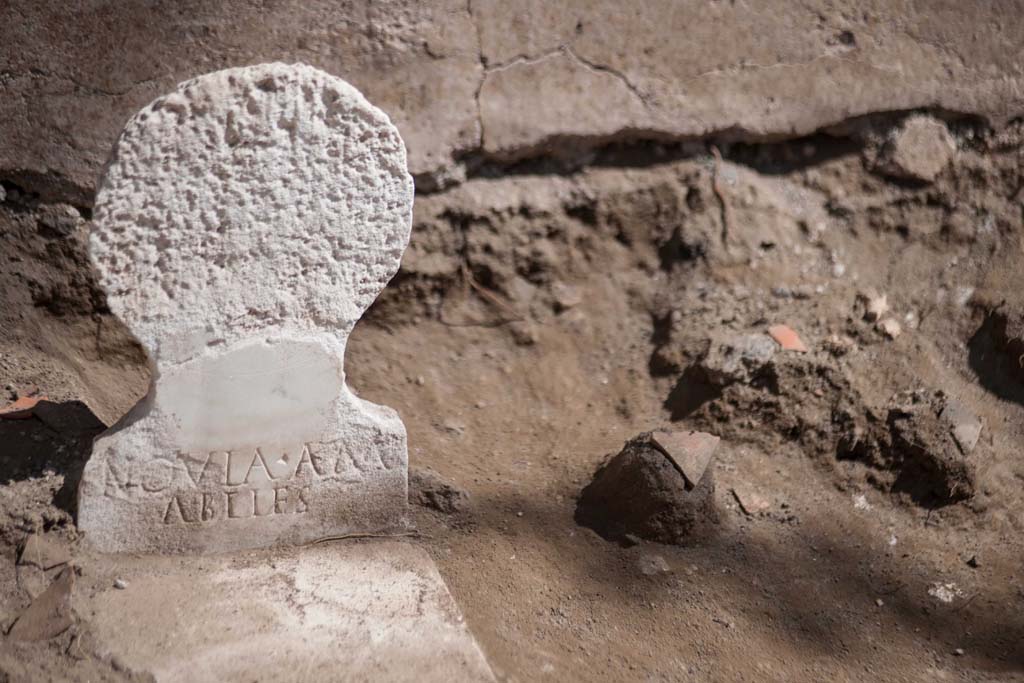
Porta Sarno la tomba di Marcus Venerius Secundio. August 2021. Tomb of Novia
Amabiles.
In the
remaining part of the enclosure evidence of cremation has been found, in the
form of two cinerary urns, one of which is a beautiful glass container
belonging to a woman by the name of Novia Amabilis.
La tomba di Novia Amabilis.
Nella restante parte del recinto sono state riscontrate
due incinerazioni in urna, una in un bellissimo contenitore in vetro appartenente
a una donna di nome Novia Amabilis.
NOVIA AM
ABILES
Photograph ©
Parco Archeologico di Pompei.
Porta Sarno la tomba di Marcus Venerius Secundio. Tomb of Novia Amabiles. August
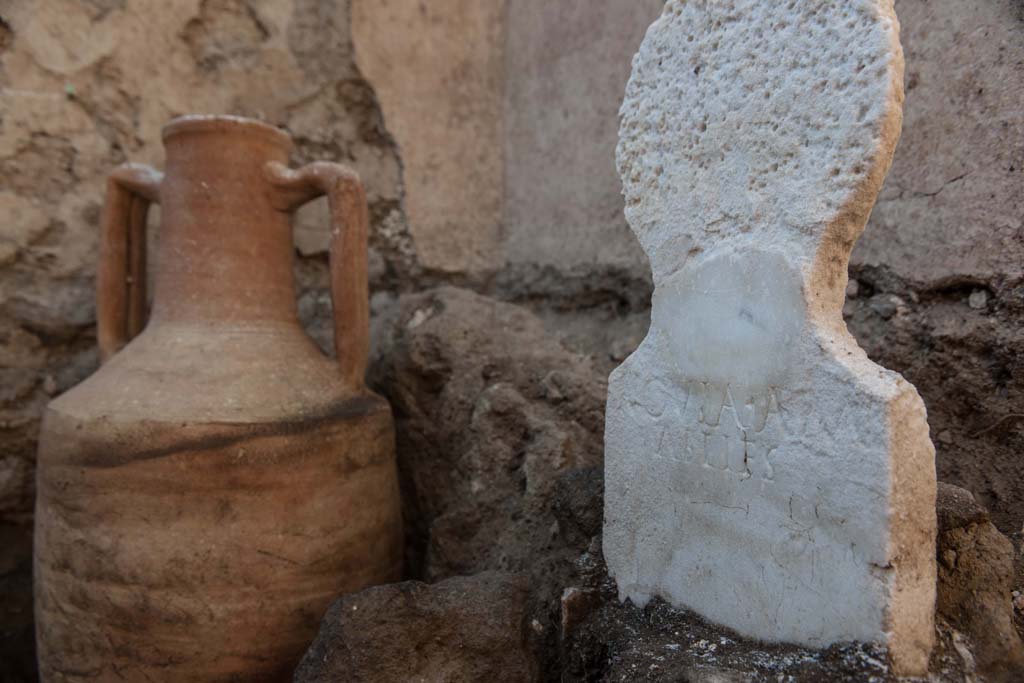
2021. Marble cippus with amphora.
La tomba di Novia Amabilis. Cippo di marmo con anfora.
Photograph ©
Parco Archeologico di Pompei.
Porta Sarno la tomba di Marcus Venerius Secundio. August 2021. Tomb of Novia Amabilis.
Marcus
Venerius Secundio was buried in a small cell of 1.6 x 2.4 metres, located
behind the main facade, while in the remaining part of the enclosure evidence
of cremation has been found, in the form of two cinerary urns, one of which is
a beautiful glass container belonging to a woman by the name of Novia Amabilis.
La tomba di Novia Amabilis.
Marcus Venerius Secundio fu inumato in una piccola cella
di 1,6 x 2,4 metri posta alle spalle della facciata principale, mentre nella
restante parte del recinto sono state riscontrate due incinerazioni in urna,
una in un bellissimo contenitore in vetro appartenente a una donna di nome
Novia Amabilis.
Photograph ©
Parco Archeologico di Pompei.
Porta Sarno la tomba di Marcus Venerius
Secundio. Tomb of Novia Amabilis. August
2021.
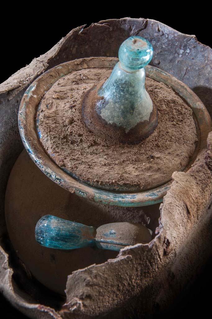
Beautiful glass
container belonging to a woman by the name of Novia Amabilis.
La tomba di Novia Amabilis.
Un bellissimo contenitore in vetro appartenente a una
donna di nome Novia Amabilis.
Photograph ©
Parco Archeologico di Pompei.
Porta Sarno la tomba di Marcus Venerius Secundio. Tomb of Novia Amabiles. March 2024.
Her cremated remains were preserved in the glass urn.
Photo courtesy of
Giuseppe Ciaramella.
On display in exhibition in Palaestra entitled – “L’altra Pompei, vite comuni all’ombra del Vesuvio”. March 2024.
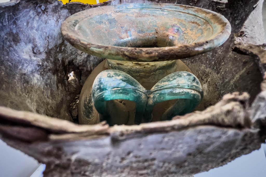
Porta Sarno la tomba di Marcus Venerius Secundio. Tomb of Novia Amabiles. March 2024. Items found in the tomb.
The tomb was found in the burial enclosure of Marcus Venerius Secundus.
Marble columella of Novia Amabiles, presumed to be the wife of Marcus Venerius Secundus.
Her cremated remains were preserved in the glass urn, together with those of two children, most likely the children of the couple.
A terracotta lamp, a bronze nail, a marble slab and glass unguentaria and a bronze coin were also found.
Photo courtesy of
Giuseppe Ciaramella.
On display in exhibition in Palaestra entitled – “L’altra Pompei, vite comuni all’ombra del Vesuvio”. March 2024.
Porta Sarno la tomba di Marcus Venerius Secundio. Tomb of Novia Amabiles. March 2024.
A terracotta lamp, a bronze nail, a marble slab and glass unguentaria and a bronze coin were also found.
Photo courtesy of
Giuseppe Ciaramella.
On display in exhibition in Palaestra entitled – “L’altra Pompei, vite comuni all’ombra del Vesuvio”. March 2024.
Porta Sarno la tomba di Marcus Venerius Secundio. August 2021. Arched tomb with two
cippi.
There appear to be painted plants on the
plaster walls inside the tomb.
Tomba a volta con due cippi.
Sembra che ci siano piante dipinte sulle pareti intonacate all'interno
della tomba.
Photograph © Parco Archeologico di Pompei.

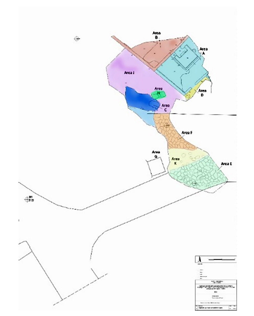
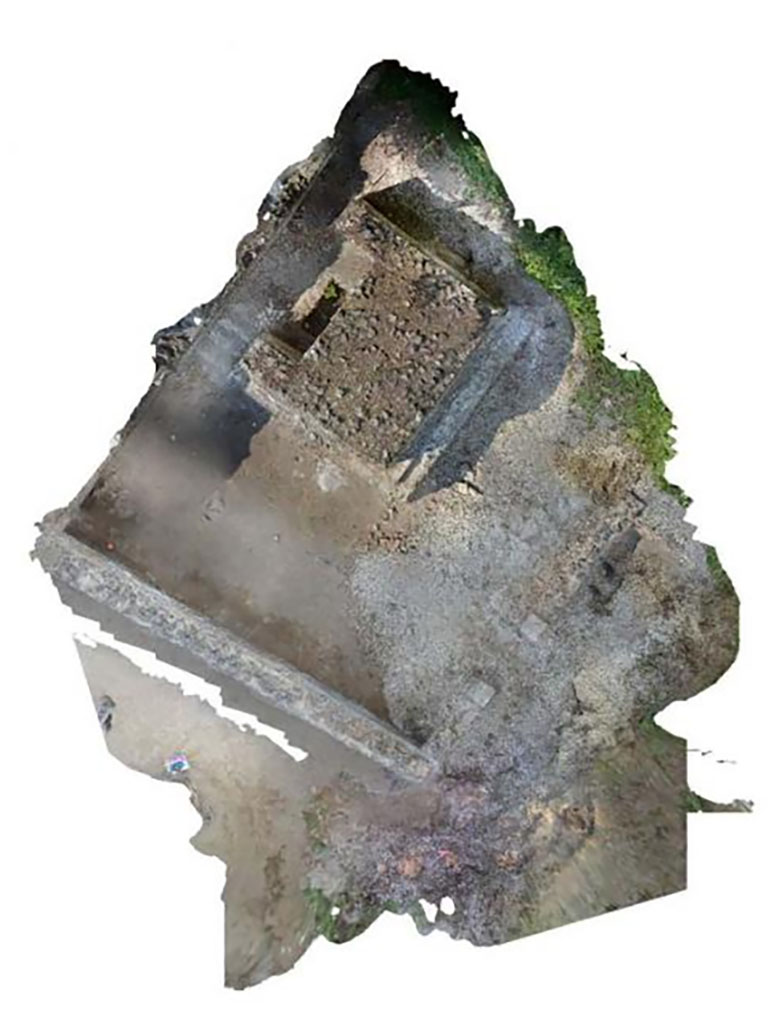
Pompeii Porta Sarno Necropolis. 2018 excavations plan.
See FastiOnline Necropoli di Porta Sarno 2018 Use subject to CC BY-SA 4.0
The space of the 2018 intervention was
divided into different work zones, where the two funerary enclosures known to
date in the necropolis stand out:
AREA A: Funerary site with a monument on podium.
AREA B: Funerary site with a monument of type “colonnato”.
The area outside these enclosures was also subdivided into
several areas:
AREA C: Samnite
necropolis.
AREA D: area east
of site A.
AREA E: via dell’Abbondanza, E-OE direction.
AREA F: auxiliary
road, N-S direction.
AREA G: Funerary
monument south of the auxiliary road.
AREA H: Praetorian
tombs area.
AREA J: space
between the funeral precincts and the area of the Samnite necropolis.
AREA K: space
between the two tracks.
The new tombs found in 2021 would be a continuation from area D.
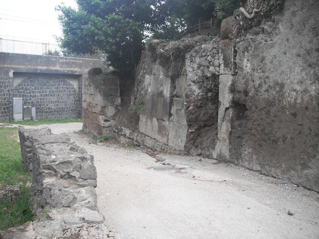
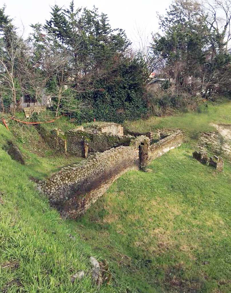
Pompeii Porta Sarno Necropolis. May 2010. Via dell’Abbondanza running through the Porta Sarno.
The road is now blocked by the railway line but would have joined the north-south auxiliary road and continued to the necropolis.
Photo courtesy of Ivo van der Graaff.

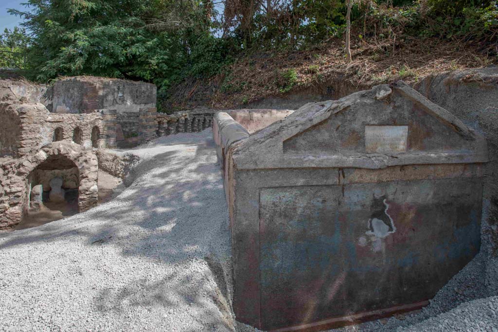
Pompeii Porta Sarno Necropolis. June 2012. Monumental tomb A (right) and enclosure with tomb B (left). Photo courtesy of Ivo van der Graaff.
Pompeii Porta Sarno Necropolis. May 2011. Monumental tomb B left and tomb A right with enclosures.
Pompeii Porta Sarno Necropolis. June 2010. Monumental tomb A (right) and enclosure with tomb B (left). Photo courtesy of Rick Bauer.
Pompeii Porta Sarno Necropolis. May 2006. Monumental tombs B and A and enclosures.
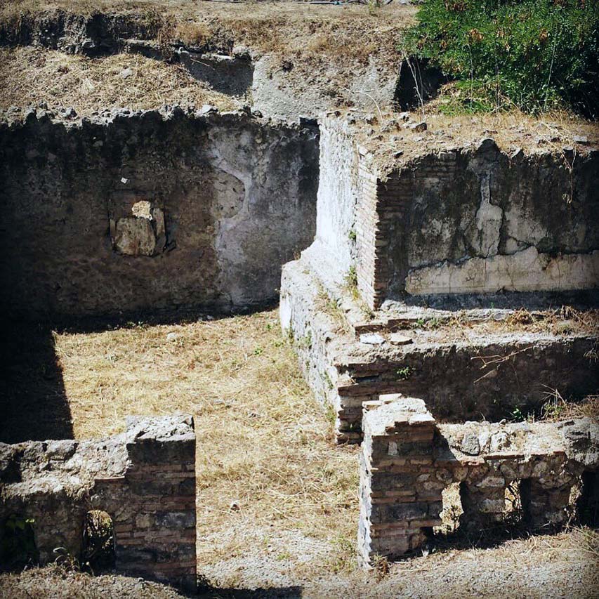
Pompeii Porta Sarno Necropolis. C.1999. Monumental tomb A.
Praetorian tombs area H is to the left with entrance to area B, funerary site with a monument of type “colonnato” behind.
Pompeii Porta Sarno Necropolis. 2018. Tomb enclosures B and A with area J to immediate
right with area H at its end.
In the hollow to the right of this are the Samnite
necropolis area C, paved area F an auxiliary road in N-S direction., area K and paved area E, the continuation of
the ancient road (now known as Via dell'Abbondanza).
The tombs are located outside the gate but are now on the other side of the railway line.
See FastiOnline Necropoli di Porta Sarno
2018 Use subject to CC BY-SA 4.0
Pompeii Porta Sarno Necropolis. 1999.
Skeleton in inhumation tomb from the Samnite period, encased in travertine
blocks.
The first
tomb explored contained a single skeleton with the head to the west. At the
feet were the grave goods, consisting of an achromatic olla, a black varnished
kylix, stamped with 6 rosettes joined by circular arcs, a black varnished
oinochoe, with a round mouth. They are, as can be seen, poor burials dating
back to between the mid-4th and the beginning of the 3rd century a. C.
Scheletro in tomba ad inumazione di età sannitica, a
cassa di blocchi di travertino.
La prima tomba esplorata conteneva un solo scheletro con
testa ad ovest. Presso i piedi era il corredo, costituito da un'olla acroma,
una kylix a vernice nera, con stampigliatura a 6
rosette congiunte da archi di cerchio, una oinochoe a vernice nera, con bocca
rotonda. Sono, come si vede, sepolture povere databili tra la metà del IV e gli
inizi del sec. III a. C.
See/Vedi Suburbio Orientale in Rivista di Studi Pompeiani X,
1999, p. 180, fig. 1.
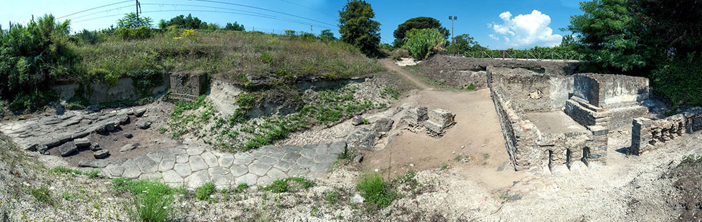
Pompeii Porta
Sarno Necropolis. Panoramic view
looking north. Tomb
enclosures A and B are on the right with area D in front and area H to its left
with area J the space between the funeral precincts and the area of the
Samnite necropolis behind it.
On the
left of the picture are paved area E, area K and paved area E with square area
G a funerary monument south of the auxiliary road still partially buried.
The continuation of the Via dell'Abbondanza, area E, the
ancient road from the gate, now blocked by the railway, is to the left running west
to east.
Photo courtesy Necropolis of Porta Sarno
Research Project.
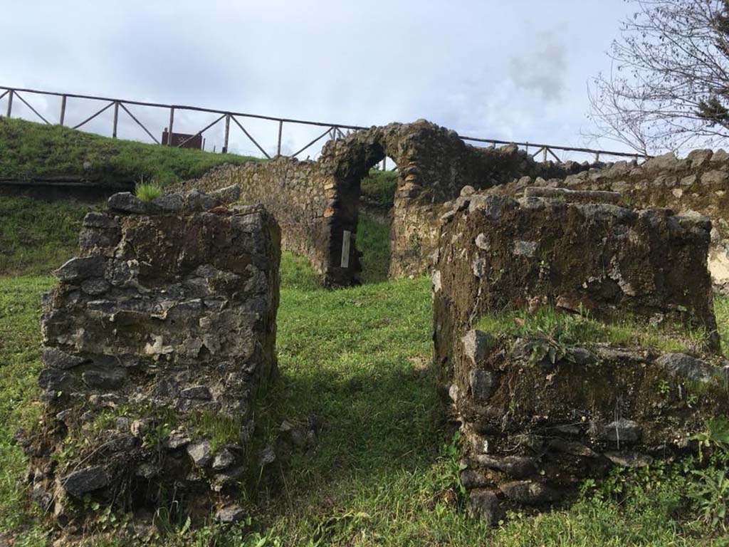
Pompeii Porta Sarno Necropolis. March 2018. Tomb area B, a funerary site with a monument of type “colonnato” is on the left with an arched entrance.
Area A is the funerary site with a monument on a podium behind tomb B, with its entrance in the far end wall.
The grassed Area J, in front of tomb B, is the space between the funeral precincts and the area of the Samnite
necropolis.
The separate stones on the far right are the area H, the Praetorian tombs area.
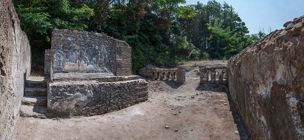
Pompeii Porta Sarno Necropolis. 2017. Tomb enclosure A, funerary site with a monument on podium.
Looking south to entrance and wall with arched openings. Photo courtesy Necropolis of Porta Sarno Research Project.
Pompeii Porta Sarno Necropolis. 2018. Podium tomb A. Funerary site with a monument on podium and
enclosure.
The
enclosure has its entrance on the south side which has a wall perforated by a
series of small arches.
Photo courtesy Necropolis of Porta Sarno Research Project.
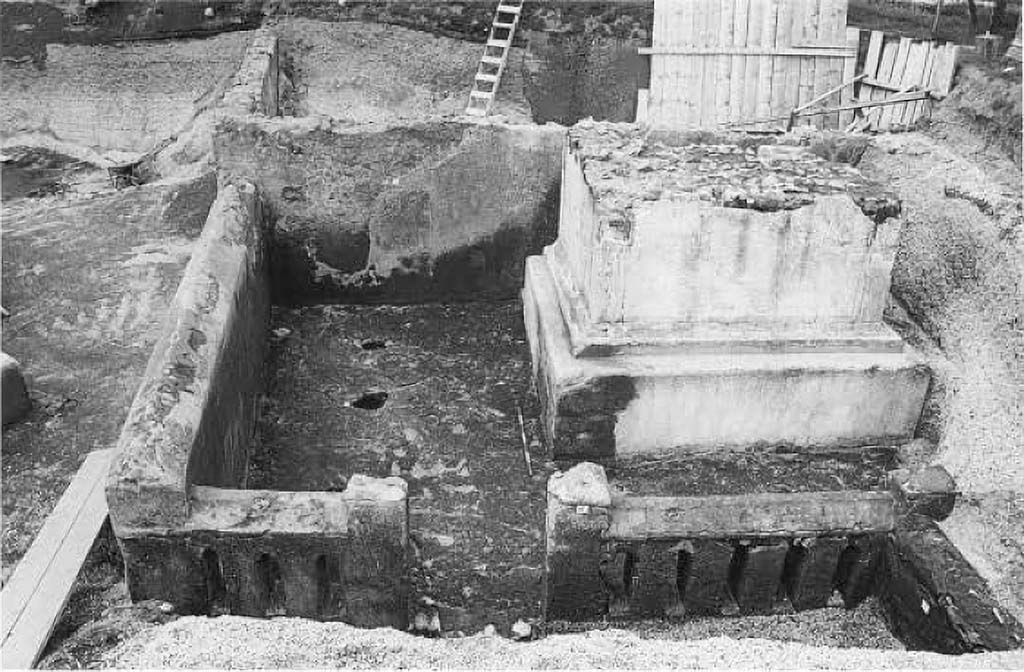
Pompeii Porta Sarno Necropolis. 1999. Podium tomb A. Funerary site with a monument on podium and
enclosure.
In 1999 a new
necropolis area was also discovered in which, in particular, is a large
funerary monument - of the "a dado" (cube) type on a podium - of
which, unfortunately, the upper part has been lost with it the epigraph that
probably must have been there, so that the owner remains unknown. The building,
in opus incerta, with corners in brick work, covered with white plaster, is contained
in an enclosure in opus incerta work, in which narrow vertical windows open. At
the base of the rear side, there is a niche, in turn containing a smaller niche
in which a columella with the related cinerary material was placed, stuck in
the ground. In the space between the enclosure and the podium, cavities
relevant to the roots of trees, probably cypresses, that surrounded the
monument were highlighted.
Nel 1999 è stata,
inoltre, scoperta una nuova area di necropoli nella quale è da segnalare, in
particolare, un grande monumento funerario - del tipo "a dado" su
podio - del quale, purtroppo è andata perduta la parte superiore e con essa
l'epigrafe che, verosimilmente, doveva esserci, così che ne resta sconosciuto
il proprietario. L'edificio, in opera incerta, con ammorsature angolari in
opera laterizia, rivestito di intonaco bianco, è inserito in un recinto in
opera incerta, nel quale si aprono strette afinestrature verticali. Alla base
del lato posteriore, si apre una nicchia, a sua volta contenente una nicchia
più piccola nella quale era posta, infissa nel terreno, una columella con il
cinerario relativo. Nello spazio tra il recinto e il podio, sono state
evidenziate cavità pertinenti alle radici di alberi, probabilmente cipressi,
che circondavano il monumento.
See/Vedi Suburbio
Orientale in Rivista di Studi Pompeiani X, 1999, p. 181, fig. 2.
Pompeii Porta Sarno Necropolis. 2017. Podium tomb A. Funerary site with a monument on podium and
enclosure. View from above.
Area D is
to the east (right) of the entrance.
See FastiOnline Necropoli di Porta Sarno 2018 Use subject to CC BY-SA 4.0

Pompeii Porta Sarno Necropolis. 2018. Area K, the via dell’Abbondanza continuation, with area F, the auxiliary road, N-S direction behind.
Photo courtesy Necropolis of Porta Sarno Research Project.

Pompeii Porta Sarno Necropolis. 2018. Praetorian tombs area H with entrance to area B, funerary site with a monument of type “colonnato” behind.
Photo courtesy Necropolis of Porta Sarno Research Project.

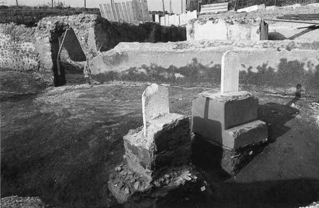
Pompeii Porta Sarno Necropolis. 1999. Praetorian tomb bases with funerary epigraphs in area H with entrance to area B behind.
A few
metres southwest of the described funerary building, there are two small bases
in opus incerta covered with red plaster, one of which is decorated with
painted geometric motifs, on the top of which a white marble slab with an
epigraph was fixed. One of them is almost completely illegible, the other one
is better preserved and mentions a Lucius Mettius Martialis, a soldier from the
Syrian city of Carre, who died at the age of 30 after 10 years of service as a
speculator:
L. METTIVS
M F POLL / MARTIALIS CARR /
SPECVL MIL
AN X VIX AN XXX.
Basi tombali pretoriane con epigrafi funerarie nell'area H con ingresso
all'area B alle spalle.
Pochi metri a sud-ovest dell'edificio funerario descritto
sono affiancati due piccoli basamenti in opera incerta ricoperta di intonaco
rosso, uno dei quali decorato con motivi geometrici suddipinti,
nella sommità dei quali era infissa una lastra in marmo bianco con epigrafe.
Quasi completamente illeggibile una delle due, meglio conservata l'altra che
menziona un Lucius Mettius Martialis, militare originario della città siriana
di Carre, morto a 30 anni dopo 10 anni di servizio come speculator:
L.
METTIVS M F POLL / MARTIALIS CARR /
SPECVL
MIL AN X VIX AN XXX.
See/Vedi Suburbio
Orientale in Rivista di Studi Pompeiani X, 1999, p. 181, fig. 3.

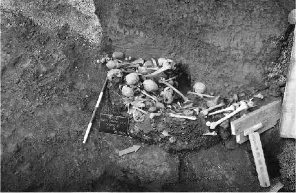
Pompeii Porta Sarno Necropolis. 1999. Deposit of human and a few animal bones.
To the
north-west of the funerary enclosure, adjacent to it, an area with structures
has been partially explored, characterised by a colonnade in opus vittata mixed
with bricks and blocks of lava stone and travertine. The state of the
structures and the accumulation, in the same place, of blocks of lava stone
that had not yet been hewn, suggest that construction or reconstruction work
was still in progress. In the escarpment that delimits this sector on the N
side, a large funnel-shaped pit (2.80 m deep, 2.70 m wide at the top and 1.50 m
wide at the base) is clearly visible in section, clearly cutting through the
eruptive stratigraphy. At the base, there is a deposit of human and a few
animal bones, apparently in a secondary position since they are not connected.
Beneath this pile of bones, are a few clay pots, also containing burnt bones.
This accumulation of artefacts, as well as the wall structures mentioned above,
both of which are of unclear interpretation, continue under the slope that
delimits the excavation. It is hoped that an extension of the intervention area
and further exploration will clarify the situation.
Deposito di ossa umane e alcune animali.
A nord-ovest del recinto funerario, a questo adiacente, è
stata parzialmente esplorata un'area con strutture, caratterizzata da un
colonnato in opera vittata mista con laterizi e blocchetti di pietra lavica e
di travertino. Lo stato delle strutture e l'accumulo, nello stesso luogo, di blocchi
di pietra lavica non ancora sbozzati, lascia pensare che fossero ancora in
corso lavori di costruzione o di rifacimento. Nella scarpata che delimita
questo settore sul lato N, è chiaramente visibile, in sezione, una grande fossa
imbutiforme (profonda 2,80 m; larga 2, 70 m alla sommità e 1.50 m alla base)
che taglia nettamente la stratigrafia eruttiva. Alla base, c'è un deposito di
ossa umane e alcune animali, apparentemente in giacitura secondaria dal momento
che non sono in connessione. Sotto questo cumulo di ossa, sono alcuni vasi
fittili, anch'essi contenenti ossa combuste. Questo accumulo di reperti, così come
le strutture murarie cui si è fatto cenno, ambedue di poco chiara
interpretazione. proseguono sotto la scarpata che delimita lo scavo. Si spera
che un ampliamento dell'area di intervento e un approfondimento
dell'esplorazione possano chiarire la situazione.
See/Vedi Suburbio
Orientale in Rivista di Studi Pompeiani X, 1999, p. 182, fig. 4.